eParking: Android Application for Finding Car Parking Area in Bhutan
Rinzin Wangdi1, Ugyen Nima2, Namgay Rinzin3, Tandin Wangchuk4![]()
Information Technology Department. College of Science and Technology, Royal University of Bhutan.
* E-mail: eit2011022.cst@rub.edu.bt1, eit2011033.cst@rub.edu.bt2, eit2012016.cst@rub.edu.bt3, tandinwangchuk.cst@rub.edu.bt4
Abstract
There is an increasing trend in number of vehicles in cities like Thimphu and Phuentsholing annually. Traffic congestion and bottleneck remain the major concern due to straying of vehicles in the cities. The vehicles stray looking for parking in the towns. Moreover, high fuel consumption, time wastage and air pollution are major issues due to vehicles straying in the town in search of parking lot especially during peak hours. To overcome this problem there is need of a system to provide parking availability information to the users in our society. On the other hand, advancement of technology such as smart phones and mobile application has made our life much easier and faster to work on time. Therefore, this paper proposes android application, which is used to implement a prototype of eParking app that allows drivers to effectively find vacant parking spaces remotely using their mobile devices.
Keywords : Google cloud messaging, android application, Smart parking, Parking area, Internet of Thing (IoT)
INTRODUCTION
Transportation is a part and parcel of any society. It exhibits a very close relation to the style of life, the range and location of activities and the goods and services which will be available for consumption. Advances in transportation have made possible changes in the way of living and the way in which societies are organized and therefore have a great influence in the development of civilizations. Transportation is responsible for the development of civilizations from very old times by meeting travel requirement of the people and transport requirement for goods. Such movement has changed the way people live and travel. In developed and developing nations, a large fraction of people travels daily for work, shopping and social reasons but on other side, transportation also consumes a lot of resources like time, fuel, materials and land. While analysing the present major modes of transportation, we have observed the short comings such as greenhouse emissions, parking problems and high investment in fuel prices.
As of 2013, it was tabulated that nearly 50% of air pollutants were from the combustion of fuels in the car. In current status result shows that more than 58% numbers of vehicles are in capital city and Phuentsholing town (Phuntsho & Kanitpong, 2010). Moreover, the emission due to an increased in a growing number of vehicles is increasing and the current trend is likely to be continued. The conversion of fuel in the car’s engine is accompanied by chemical waste in the form of smoke which comprises of particulate matter (PM), nitrogen oxides (NO2), carbon dioxide (CO2), carbon monoxide (CO), sulphur oxides (SO) and other smog-forming emissions which are considered as greenhouse gases.
The pollution is a recurring cause of many problems related to health and state of the environment. The pollution level seems to be negligible on individual accounts; however the cumulative effect of it would be a part of the city’s pollution and carbon dioxide content. About 28% of carbon dioxide emissions in Bhutan comprise of that from the vehicles (MOIC, 2015). In the past years we have witnessed a huge increase in vehicle import beside taxation law. This concludes that, the major source of transportation in the cities continues to be privately owned vehicles, even though the government’s initiative of public transport has been in service. With this enormous number of vehicles on the route, there is an acute problem of parking space and traffic congestion in the town. The private vehicles are most likely to suffer the problem of parking since the taxi’s and heavy vehicles such as trucks have a designated space for parking.
MOTIVATION
A study to implement an Intelligent Transport System (ITS) in Thimphu city has identified several causes for traffic congestion occurring in the capital (Dorji, 2015). One of the key issues was car parking in the study. Dorji (2015) focuses on the usage of technology to increase the efficiency of traffic management by improving public transport services, implementation of congestion management strategies, convincing more people to use public transport, walk and bicycle. Beside this, they have also suggested some solutions to manage traffic congestions but not all drivers are ready to agree with it. On the other hand, there are some real time apps which are developed using wireless sensors in the developed countries like management of the transportation system, application in the field of logistic and traffic management systems.
With the increasing trend of vehicles in the country, the increasing level of air pollution is a threat. The International Institute for Environment and Development, a London-based research organization has listed Thimphu city in the world’s 15 most vulnerable to the impacts of global warming (Wangchuk, 2011). These problems are due to the improper management and due to the lack of information provided to the car owners in the real time. Thus, there is need of public information or real time information that has to be provided to the customers in order to reduce pollution from cars for finding vacant parking area in the town.
Moreover, a group of final year students from Electronics and Communication Engineering Department has carried out this proposed study and demonstrated a prototype model for the single vacant spot (Wangmo, Gajmir, & Shingdan, 2014). Though the project carries similar targets in reducing the fuel consumption, the group focused more towards micro-level prototype for just three parking slots using simple electronic elements. This prototype model was able to detect the vacant slot but it was not the challenge arises when two cars are competing for the same vacant slot. Such decision making for the car drivers can be optimized using mobile application and with the introduction of mobile apps can be helpful in obtaining up to date information of the parking area at anytime and anywhere.
PROBLEM DESCRIPTION
Parking has been a social and technical problem since the early days of rapid increase in the number of vehicles in cities like Thimphu and Phuentsholing. Traffic congestions, fuel consumption and air pollution are the major concern in regards to the availability of the parking information. In the current situation, these two cities are experiencing huge traffic congestion problems, especially during early morning and evening. Moreover, the increased in number of parking demand and limited parking area, information are always the main factors.
Moreover, a team of London-based research organization has reported that Thimphu, the capital city of Bhutan has been listed in the world’s 15 most vulnerable to the impacts of global warming (Wangchuk, 2011). The ultimate reason for global warming is due to the emission from the increased number of vehicles and also due to the straying of the vehicles in the town searching for free parking spaces.
With the increased in automobile-dependency, the end users are faced with traffic congestion due to insufficient information being provided to the drivers. Moreover, there is unnecessary wastage of fuel, time and resources in search of free parking slot. To describe more positively, efficient parking management can provide significant increase in economic, social and environmental benefits, but in absence of parking information would lead the drivers to spend unnecessarily large amount of time searching for the empty slots. Another problem is that drivers often end up finding the same parking spot at the same time. While one would get the empty spot and reap the benefits from his search time, the other drivers search time is completely wasted.
RELATED WORKS
A mobile phone–based parking system requires the support of other modules for them to have optimal performance. These modules may include a sensor to provide updates on the traffic situation on the streets and in the parking spaces (Kinyanjui & Kahonge, 2013). This section provides insight into the use of mobile phone-based systems elsewhere in the world as well as the sensor technologies used
Mobile based Parking System
A similar application developed in Berlin, Germany is aimed at creating demand dependent pricing schemes in the future (Kinyanjui & Kahonge, 2013). In 2004 only a large number of on-street parking machines were in use and allowed for payment of parking fees in Berlin. A mobile parking system designed by Mobile Parking GmbH focused on implementation and demonstration of a system using innovative cellular phone technologies. Apart from the drivers, other people can use their mobile phones for this service.
A service centre registered automatically the parking duration times of the users and charged them in accordance with the time they have parked. City officials received all the anonymous statistical data of parking transactions that have occurred within their jurisdiction.
The flexibility, efficiency and the acceptance of the mobile parking system were demonstrated and evaluated under real world day-to-day conditions. By 2005 more than 6,800 users were registered. Approximately 600 mobile parking transactions per day were executed.
Technology and Sensors used
Sensors form an important component of automated parking systems. The literature below provides insight into the various sensor technologies. It also provides the basis for support of a locally developed solution.
A similar application describes the architecture and design of parking system, a mobile sensor network consisting of vehicles, which collects and disseminates real-time information about the availability of parking spaces in urban areas (Mathur, Kaul, Gruteser, & Trappe, 2009). The detailed outline and the broad challenges in real-time data collection and consumption by a mobile sensor network, as well as the design issues specific to parking system are discussed. They discuss on the deployment of low cost ultrasonic sensors to detect the presence of vacant parking spots as they drive by.
Real-time parking availability information is important in urban areas, and if available could reduce congestion, pollution, and fuel consumption. Here, Stenneth and his group provide an advanced street parking system called PhonePark (Stenneth, Wolfson, Xu, & Yu, 2012). The phonepark is developed by using the GPS, accelerometer, and Bluetooth sensors on a traveler’s mobile phone, in conjunction with geospatial data, where travels can automatically detect when and where they parked their car, and when they released the occupied parking slot.
CURRENT SCENARIO IN BHUTAN
The In this section, we present the current scenario in Bhutan in terms of technology advancements and the services that can be accessed by the people at minimum cost.
Number of vehicles
Number of vehicles in the country has increased over the past five years. This statistical result collected from the Road and Safety and Transport Authority of Bhutan shows that the trend is likely to continue over the period of the time (RSTA, 2016). As depicted in Figure1, there is subsequent increase in number of vehicles within the period of six years.
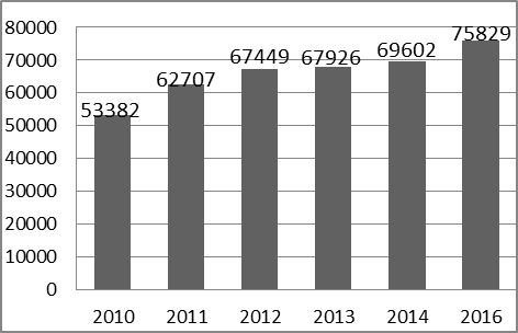
Fig.1 Total number of veihcles as January, 2016
Number of Mobile Users
Globally, there is increasing trend in the number of mobile users. Likewise, there is also an increase in number of mobile phone users in Bhutan (MOIC, 2015). Furthermore, an annual report on Annual Info-Comm and transport Statistical Bulletin, 2015 shows that there is increased in number of mobile phone subscribers in the country.
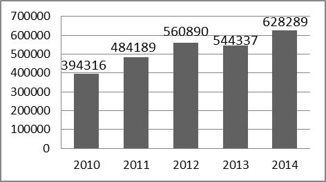
Fig.2 Total number of mobile phone subscribers as of 2014
Number of vehicles in Urban Area
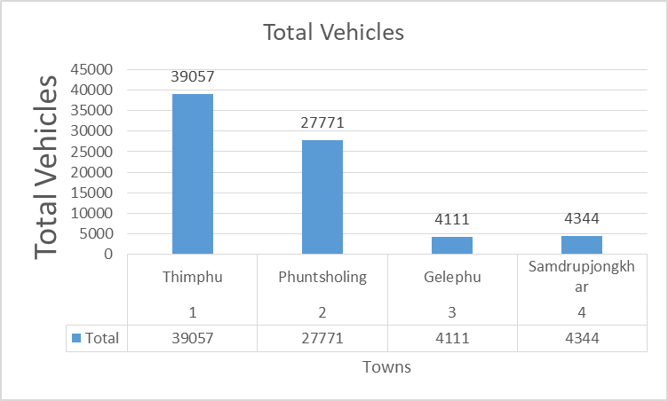
There is increase in the number of the vehicles in the major cities like Thimphu, Phuntsholing, Gelephu and Sumdrup Jongkhar. As of January 2016, the Road Safety and Transport Authority of Bhutan have seen a large number of vehicles entering to these cities. This has led to the time consumption of the driver searching for the parking spaces and ultimately producing huge amount of pollution to the environment.
Table 1 Total number of vehicles distribution
Number of internet users
Real time parking information can be provided from a web server with the usage of internet. Ministry of Information and Communication of Bhutan have found that there is increase in number of internet users as shown in the Fig.3. With these increase, people can have better access to information. Therefore, a well-developed integrated parking application can be used by all the drivers to find an available parking slot.
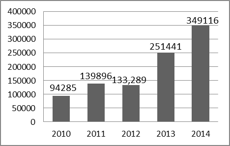
Fig.3 Internet subscription as of 2014
Services available in Bhutan
Service providers like Bhutan Telecom and Tashi Cell Company offers internet services to the mobile users. Beside the broadband, they provide services like 2G, 3G and recently they offer 4G to some part of Bhutan. The 4G was launched aiming to serve the customers with high speed data and mobility. Further, it would enhance the download speed of the data tremendously since there is need of good internet connection to access the parking information.
Our study concludes that the required resources for implementing parking system are available and can be achieved with the minimum cost. Therefore, in the following sections, we present the proposed features of the car parking application and its results.
PROPOSED FEATURE
In order to reduce the issues like traffic congestion, we proposed a mobile application which will assist the driver to find parking slots. The mobile application is developed specifically to use on small, wireless computing devices such as smartphones and tablets to access information anywhere and anytime. We have defined our scope within the development of:
- We will focus on developing and testing the App within the parking areas in college campus
- The application should display the current location
- The application will show the nearest parking area from your current location
- It should provide a navigation path to the destination (i.e. parking area)
- Able to find the location and information of the parking area
- Able to calculate the minimum time required to reach at that parking slot
Routes and Map Module
The first module provides the users about the route information from source to destination on the map, using an open source library. These allow the users to find the shortest path to the intended destination by providing a polygonal path over the map layer.
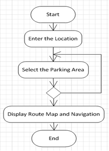
Fig.4 Represent Route Flow
Current Location and Parking Area
Here, the user can make a custom parking area selection as per the user’s needs. The application provides the users with all the available parking slots with the help of markers. The GPS in mobile devices provides the current location of the devices which helps the users to find the exact location of the users.
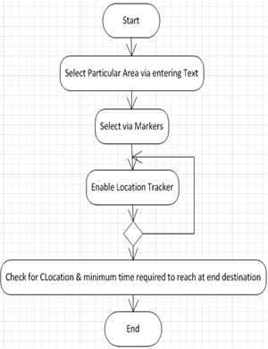
Fig.5 Represents Current Location
SYSTEM ARCHITECTURE
This section presents the system architecture of the proposed solution, i.e. eParking application. As shown in Fig.6 it is a three tier system where web server provides the parking information to the android application and the client the views these information through the mobile application.
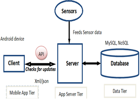
Fig.6 Represents System Architecture
Client
Client system allows the users to remotely interact with the system. User interacts with the system through the interfiace provided by the android application.
Sensor Data
The sensor embedded into the parking slots checks the availability of parking area. These information is then passed to the webserver which is used by the android application to display the free parking slots to the users.
Web server
Web server fetches the data from the sensors and provides these information to the mobile application. It is also responsible for updating the database with the latest sensor data in real time.
Database
Here, all the parking information are stored which is collected by the sensor. This information consists of the parking id, parking availability information and other parking related information. It provide a dynamic way to interact with the users by providing the frequent update of the parking information.
IMPLEMENTATION
This section presents the results of an android application developed for finding parking slot. We present the available features in our mobile application.
Home and Home menu
The application displays a list of menu options which the user can click on. It provides a convenient way for the users to interact with the application as one can also swipe through the screen to display this menu options. The home option provides a convenient way to search for the intended parking location.
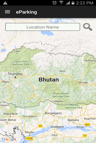
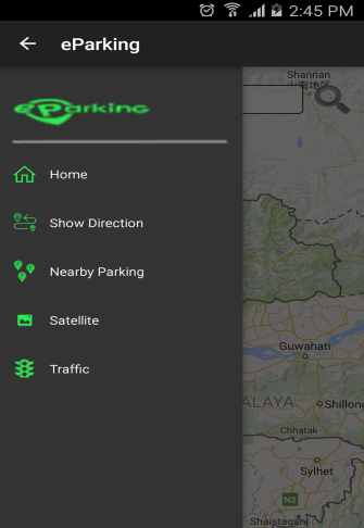
Fig.7 Represents Home and Welcome Screen
Current location of the driver
This feature of the application allows the driver to find his or her current location. It plays a vital role for the drivers when they are travelling to the unknown places. Further, it helps in finding minimum time required to reach at the selected parking area.
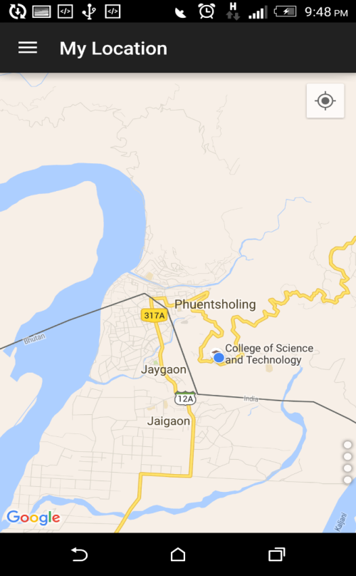
Fig.8 Represents My Location
Nearby parking area
All the available parking area is listed by a marker. This marker also allows the users to select the particular parking area to avail for other additional information. This information about the nearby parking area can either be displayed on street view or traffic view. It further enhances the reliability of the provided information.
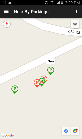
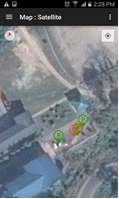
Fig.9 Represents Traffic and Satellite View
Route direction
Here, the user can enter the name of the starting and destination point of the parking area as per their requirement. The application further enhances the user experience with the help of an auto-complete field which provides related suggestion about the parking location. Further, it provides the route information and helps in navigating users to the intended parking area.
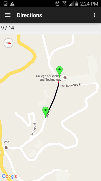
Fig.10 Represents Route Search
CONCLUSION
As of the studies carried out by the London Based Research Organization (Dorji, 2015), it is clear that there is no such system to manage the parking area being implemented while the numbers of vehicles keep on increasing in Bhutan. So, we conclude that there is a need of smart integrated system where a driver can find a free parking slot to park his or her car.
Finally, we conclude that empty parking slot information can be gathered effectively while travelling or before reaching the parking lot using smart phone application so that fuel and time consumption is saved. Moreover, we conclude that user can access the information of the parking area in an efficient and effective way.
FUTURE WORKS
In this paper, the implementation of android application for finding free parking slots is discussed. The module implemented in the application provides an efficient output as expected by the end users. Moreover, the interface establishes an effective communication across the overall working system.
In future, certain changes can be incorporated as per the requirements of Bhutan. They are:
- Searching for most reliable data from database about the parking can be improved.
- incorporation of payment system would increase the efficiency in slot distribution to the users.
- Login facility can be provided to the users
- Reliable database can be designed for the storage of large number of data.
ACKNOWLEDGEMENT
We would like to thank the management of the College of Science and Technology for their assistance and support. Additionally, we would like to thank Information Technology Department staffs and Electronic Communication Department for guiding us during our work. We would also like to thank all the people who gave us support and rendering help during our work.
REFERENCES
Dorji, G. K. (Producer). (2015). Tackling traffic jams. Kuensel. Retrieved from http://www.kuenselonline.com/tackling-traffic-jams/
Kinyanjui, K. E., & Kahonge, A. M. (2013). Mobile Phone–Based Parking System. International Journal of Information Technology, Control and Automation, 3.
Mathur, S., Kaul, S., Gruteser, M., & Trappe, W. (2009). ParkNet: a mobile sensor network for harvesting real time vehicular parking information. Paper presented at the Proceedings of the 2009 MobiHoc S<sup>3</sup> workshop on MobiHoc S<sup>3</sup>, New Orleans, Louisiana, USA.
MOIC. (2015). Annual Info-Comm and Transport Statistical Bulletin. Retrieved from http://www.moic.gov.bt/wp-content/uploads/2016/05/2015.pdf.
Phuntsho, S., & Kanitpong, K. (2010). Vehicle Emission Control Strategies and Public Opinion in Bhutan. Transportation Research Record: Journal of the Transportation Research Board, 2157, 103-110. doi:10.3141/2157-13
RSTA. (2016). Vehicle Statistics. Retrieved from Road Safety and Transport Authority website: http://www.rsta.gov.bt/rstaweb/load.html?id=82&field_cons=MENU
Stenneth, L., Wolfson, O., Xu, B., & Yu, P. S. (2012, 23-26 July 2012). PhonePark: Street Parking Using Mobile Phones. Paper presented at the 2012 IEEE 13th International Conference on Mobile Data Management.
Wangchuk, D. T. (Producer). (2011). Bhutan’s Capital, Thimpu, Facing Environmental Challenges Retrieved from http://urbanemissions.blogspot.in/2011/06/bhutans-capital-thimpu-facing.html
Wangmo, T., Gajmir, S., & Shingdan, C. (2014). Green Parking, Final Year Project Report. (Report), College of Science and Technology.