WIRELESS SENSOR NETWORK BASED LAND SLIDE DETECTION AND EARLY WARNING SYSTEM.
Ngawang Galley1, Tashi Yangzom2, Ugyen Tshering3, Kamal K. Chapagai4![]()
Electronics and Communication Engineering of College of Science and Technology, Royal University of Bhutan
*E-mail: kamal.cst@rub.edu.bt, ece2011014.cst@rub.edu.bt1, ece2012023.cst@rub.edu.bt2, ece2011029.cst@rub.edu.bt3
Abstract
The journal is based on a landslide early warning system using wireless sensor network. A brief study on the landslides and its types were made before studying the system itself. This research includes the construction of a wireless data connection network using sensors, ZigBee and microcontroller. Three sensors i.e. temperature, soil moisture and angle sensor, are connected to the Arduino UNO processor for collection of data. The data collected by Arduino is then sent through ZigBee. The information received in the base station is displayed through LCD, for real time monitoring.
Key Words: WSN, ZigBee, Arduino UNO, sensors and LCD
INTRODUCTION
Landslide is common natural phenomenon that causes significant damage to the environment and the livelihood. Many people have lost their lives and most of their properties just because of the landslide. In order to reduce and prevent the damage of landslides, landslide monitoring system is very important. It predicts and estimates landslide so that the people around can be in the safer side. Landslide monitoring is more important in hilly areas such as Bhutan. Therefore it is vital that for such places landslide monitoring system do some magic.
Wireless sensor network is one of the technologies that can quickly capture, process and respond to rapid changes in data and transmit to the receiver side. However, the wireless sensor network has its own limitations such as relatively low amounts of battery power and low memory availability.
ZigBee has been used as a medium which transmit and receive signals continuously for monitoring landsides and avalanches. For ZigBee based systems the data accuracy and reliability is primarily dependent on the distance (within its range) of the base station from the transmitter and also on the power supply that must be fed on it continuously. It is composed of a series of sensors which can
be easily installed and positioned directly upon the landslide body to provide continuous data on the landslide activity.
LANDSLIDE
Landslide is a general term used to describe the downslope movement of soil, rock and mud under the influence of gravity (Rames, , Kumar , & Venkat ). Some of the most common landslides that occur in Bhutan are:
-
- Rotational Landslides: Here the surface of rupture is curved concavely upward (spoon shaped), and the slide movement is more or less rotational.
- Translational Landslides: Here the mass of soil and rock moves out or down and outward with little rotational movement or backward tilting.
- Topple: Here a block of rock that tilts or rotates forward and falls, bounces, or rolls down the slope. (Melanie, November 2014).
The types of landslides vary with respect to the:
-
- Rate of movement: This ranges from a very slow creep (mm/year) to extremely rapid creep (m/sec).
- Type of material: It is composed of bedrock, unconsolidated sediment and/or organic debris.
- Nature of movement: The moving debris can slide, slump, flow or fall.
Landslides constitute a major natural hazard in Bhutan that accounts for considerable loss of life and damage to communication routes, human settlements, agricultural fields and forest lands ( Hinge, Ramesh , & Hinge, 2014). In Bhutan, landslides are mainly caused due to heavy rainfalls and earthquakes, so the base of this project is related to the humidity of the soil and slope of the land with the help of a wireless sensor network.
SYSTEM ARCHITECTURE
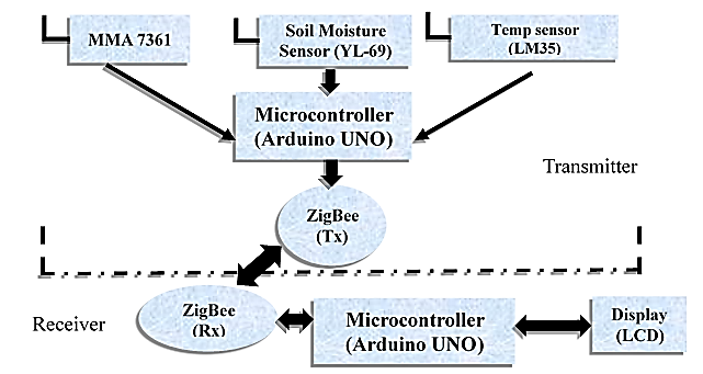
Fig. 1 System Architecture
Wireless Sensor Network (WSN) is an integrated system that consists of a group of sensor module node distributed and connected wirelessly on network topology which functions in extracting much information that is going to be processed according to its application mode.
When landslides occur, all the three sensors i.e temperature, angle and the soil moisture sensors senses the changes and transfer data through router which is the Arduino microcontroller to the coordinator which is the ZigBee module. Coordinator receives the data from the microcontroller and it is transmitted by ZigBee to the Control center. ZigBee in the Control center receives the information and through Arduino in the control center an early warning signal is being displayed in the LCD display.
SENSOR AND TESTING
LM35 (Temperature Sensor)
The LM35 measure any change in the temperature of the soil. The testing of this sensor is done though Arduino on the serial monitor and by directly connecting the sensor output to the multi-meter. From both testing it has been found that as the temperature increases the output voltage increases proportionally; for every 10 C the output voltage will change by 10mV.
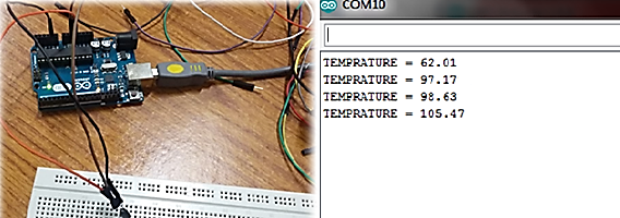
Fig. 2: Testing of LM35
YL 69 – Soil moisture sensor
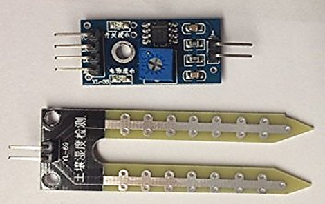
Fig. 3 YL-69
Moisture sensor is used to measure the moisture content in the soil since the moisture level increases due to heavy rainfall and will sense if there are any disturbances in the area. So this sensor measures the moisture in the soil using a 5v power supply, and is tested with a dry soil at first, then gradually increasing the water levels. A peak point is set on the program so as to alarm when there are more water content in the soil, leading to high chances of landslide.
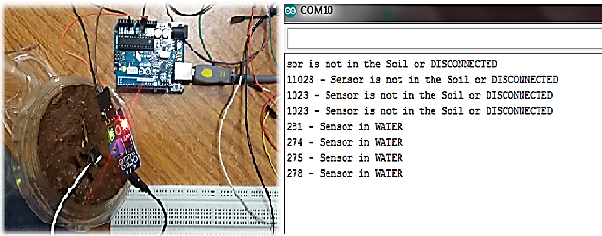
Figure 4: Testing of YL69
The figure above shows the testing of YL69. Through the testing of YL69 it is found that with the increase in the soil moisture the output voltage decreases.
MMA 7361 – Angle sensor
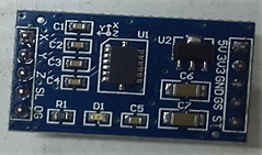
Fig. 5 MMA 7361
The MMA 7361 is the sensor for the change or disturbances in the slope of the land. The sensor is tri-axial where it takes three analog inputs that are the X-axis, Y-axis and Z-axis (Anonymous, n.d).
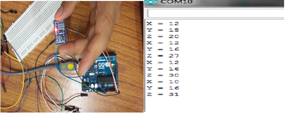 Fig. 6 Testing of MMA7361
The above figure shows the manual testing of the MMA 7361.The tri-axial outputs of MMA 7361 i.e X, Y, Z are successfully obtained in the output. As the angle of the MMA 7361 was changed, the values of X, Y and Z changed accordingly every after 6 seconds (time delay).
ARDUINO UNO R3
It is a microcontroller board based on the ATmega328 with 6 analog inputs, 14 digital input/output pins, a 16 MHz crystal oscillator, a USB connection, a power jack and a reset button. It has a memory of 32 KB (Anonymous, Arduino UNO, n.d).
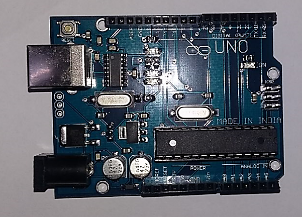
Fig. 7 Arduino UNO R3
This microcontroller performs the action of connecting the sensors with the ZigBee in the transmitter and also connects the ZigBee with the LCD at the receiver. All the three sensors are tested separately though the Arduino.
ZIGBEE
ZigBee is the name of a wireless protocol maintained by the IEEE 802.15 standard and it has an approximate range of 10 to 100 meter (Benkic, Planinsci, & Cucej, Custom Wireless Sensor based on ZigBee, 2007).
The ZigBee configuration was successfully done before using it in the project; the messages sent from the transmitter were received in the receiver.
LCD
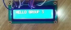
Fig. 8 LCD
A 16×2 LCD display is very basic module and is very commonly used in various devices and circuits. The LCD is used instead of a buzzer in the project to give a visual alert of the landslide that is detected to the people nearby.
As shown in the figure above the testing of the LCD was done using Arduino.
Power supply
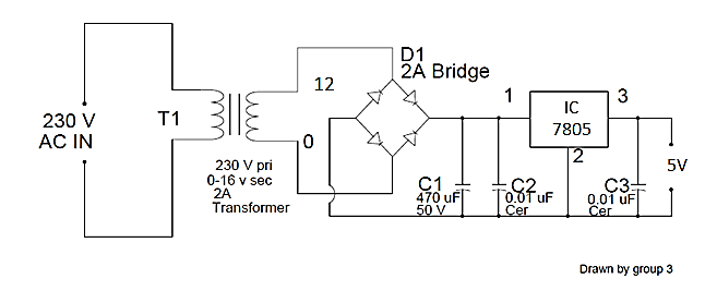
Fig. 9 Power Supply
The power supply circuit that is designed for this project generates 5V dc using a 7805 regulator. Initially the supply is step down from 230V to 12V through a step down transformer. This unit consists of a step down transformer, 7805 regulator, rectifying diodes and filter.
Simulation
Simulation of this project includes the simulation of the power supply and the simulation of the complete network. All the simulations were completed in PROTEUS.
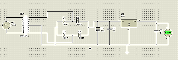
Fig. 10 Simulation of the Power Supply
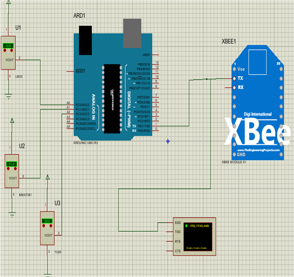
Fig. 11 Transmitter circuit
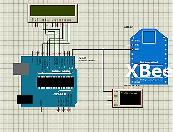
Fig. 12 Receiver Circuit

Fig. 13 Simulation Outputs
Prototype
The figure below shows the normal system when all the values of the three sensors were below their threshold point. The output on the LCD is Normal.
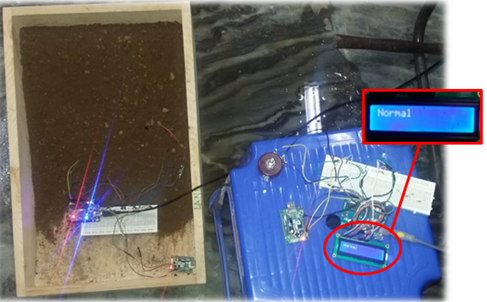
Fig. 14 Normal
As the slope of the wooden box was changed gradually and water was added simultaneously on the area where the moisture sensor was placed, landslide was displayed in the LCD just before the soil slide down in the wooden box.

Fig. 15 Landslide
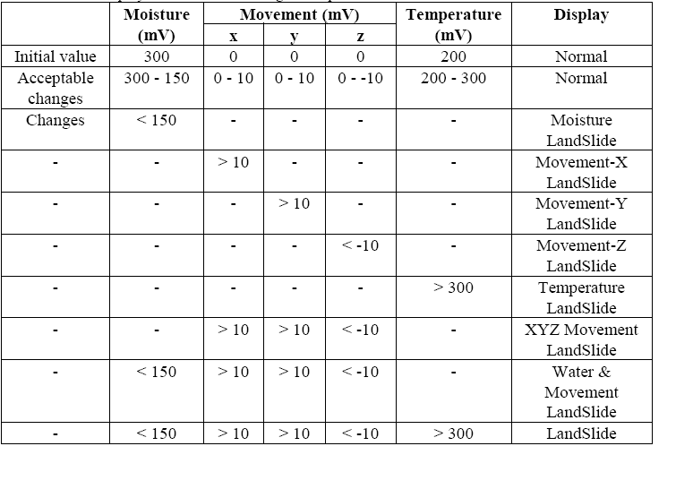 Table 1 Display on the LCD for changes in input of each sensor received in Serial Monitor.
CONCLUSION
The landslide detection system using WSN is capable of continuous monitoring of different prevailing parameters of landslide such as rainfall, changes in the slope of the area, moisture level, and providing different levels of alarm to the local residents so as to evacuate the place of impending landslide. All the activities that are involved in completing this project can be categorized into two major tasks that is the software and hardware development. The first task is the software development. Due to the features like flexibility in programming, high performance, low cost and low power consumption of Arduino, the programming of Arduino has been developed with the assigned time. The simulation of the entire circuit could also be done with not much of difficulty in freely available software named PROTEUS.
The second major phase that is the hardware development mainly includes construction of the designed circuits, the power supply circuit and the main system circuit. With the hardware implementation the testing of the entire system was successful and the result was positive.
FUTURE SCOPE
The system design communication is via ZigBee, use of GSM is also implacable for such system. The precise threshold values for each of the sensors can be obtained through detailed study on the landslides and type of soil that the system is to be implemented in. Application of such system can also be developed in future by collaborating with IT department.
ACKNOWLEDGEMENT
We would like to express our gratitude to Mr. Kamal Kumar Chapagai, Assistant Lecturer College of Science and Technology for guiding us through the entire project. Special thanks to Dr. Kazuhiro Muramatsu, for helping us in completing this project.
REFERENCES
A.Kuhn, K. (2009). Introduction To Voltage Regulators.
Anonymous. (n.d, n.d n.d). Retrieved from pentechsolutions.net: http://www.pentechsolutions.net
Anonymous. (n.d). Retrieved from https://www.google.bt/?ion=1&espv=2#q=freescale+semiconductor+technical+data+MMA7361
Anonymous. (n.d). Retrieved from http://forum.arduino.cc/index.php?topic=84190.0
Anonymous. (n.d). Arduino UNO. Retrieved from Arduino UNO: http://datasheet.octopart.com/A000066-Arduino-datasheet-13286688.pdf
Anonymous. (n.d, n.d n.d). Comparision of Wireless Technologies.
Arduino UNO. (n.d.). Retrieved from Arduino UNO : http://datasheet.octopart.com/A000066-Arduino-datasheet-13286688.pdf
B, K. Y., Mallapur, J. D., H, S. P., & P, S. (2012). Angular Variation Methodology for Landslide Measurement. Fourth International Conference on Computational Intelligence, Communication Systems and Networks (pp. 47-52). Bagalkot: Basaveshwar Engineering College.
Baishun, S., Zhengduo, P., & Guoying, M. (2010). Design of the mine gas Sensor based on Zigbee . Third International Symposium on Computer Science and Computational Technology (pp. 77-81). Jiaozuo, China: China University of Mining and Technology.
Benkic, K., Planinsci, P., & Cucej, Z. (2007). Custom Wireless Sensor based on ZigBee. 49th International Symposium ELMAR, 1.
Benkic, K., Planinsic, P., & Cucej, Z. (september 2007). Custom Wireless Sensor Network based on ZigBee . Croatia: International Symposium ELMAR-2007.
Chan, W. T., Roschelle, J., Hsi, S., Kinshuk, Sharples, M., Brown, T., & et al. (2006). One-to-one technology-enhanced learning: An opportunity for global research collaboration. Research and Practice of Technology Enhanced Learning, 1(1), 3-29.
ebay.in. (2016). Retrieved from ebay.in: http://www.ebay.in/itm/XBee-ZigBee-Adapter-board-with-USB-interface-/231479613006?hash=item35e542964e:g:f4UAAOSw9N1VzJCC
Finkenzeller, K. (2003). RFID Handbook Fundamentals and Applications in Contactless Smart Cards and Identification. Chichster: John Wiley and Sons Ltd.
Fun, S. (n.d.). XBee 2mW Wire Antenna – Series 2 (ZigBee Mesh). Retrieved from XBee 2mW Wire Antenna – Series 2 (ZigBee Mesh): https://www.sparkfun.com/products/10414
Garcia, R. R. (n.d). Understanding the Zigbee Stack.
Girty, G. (2009). Perilous Earth: Understanding Processes Behind Natural Disasters. San Diego: Department of Geological Sciences.
Interior, U. D., & Survey, U. G. ( 2004, July). Landslide Types and Processes.
International, D. (2008, november). XBee ZNet 2.5/XBee PRO Znet 2.5 OEM. Minnetonka.
K, R. (2011). Power supply Design.
Khalichi, B., & nikmehr, S. (2015). International journal of electronics and communications. development of novel wideband H-plane horn antennas by employing asymmetrical slots based on SIW technology.
Kumar, S. D., & Naidu, V. J. (2015). Landslide Detection and Monitoring Using Mems and Zigbee. SSRG International Journal of Electronics and Communication Engineering , 57-64.
Kumar, S., & Lobiyal, K. D. (2012). An Enhanced DV-Hop Localization Algorithm for Wireless Sensor Networks. International Journal of Wireless Networks and Broadband Technologies, 2(2), 16-35.
Kunnath, A. T., & Ramesh, M. V. (2010). Integrating Geophone Network to Real-Time Wireless Sensor Network System for Landslide Detection. First International Conference on Sensor Device Technologies and Applications (pp. 167-171). Kerala: AMRITA University.
L.Floyd, T. (1996). Electronic Devices. New Delhi: Prentice Hall Inc.
L.Floyd, T. (1996). Electronic Devices. New Delhi: Prentice Hall Inc.
Little, F. E. (n.d.). Solar Power Satellites: Recent Developments. Technology Report, Texas A& M University, Centre for Space Power, Texas.
Melanie. (November 2014). Landslide and mitigation.
Mishra, P. K., Shukla, S. K., Dutta, S., & Chauly, S. K. (2011). Detection of landslide using wireless sensor network. Central Institude of Mining and Fuel Research, 2.
Nayak, B. (september, 2011). Wireless Sensor Network. Kharagpur : Indian Institute of Technology.
Nirwana, H., Zainuddin, Z., Z, Z., M, M. B., Tola, M., Harun, N., . . . Andani. (2013). Communication System Modeling Of Wireless Sensor Networkk For Early Landslide Detection. Internaitonal Journal Of Engineering Research and Application , 2412-2417.
Njoroge, K. P. (2008). Microcontroller Based Irrigation System. Architecture and Engineering.
Patil, D. S. (n.d). User manuel blueboard LPC214X-H. Bangolore: NGX pravite limited.
P. N., Ramesh , R. B., & Hinge, P. N. (2014). wireless sensor network for detecting vibrations before landslides. international journal of engineering and technology, 26.
Rames, , M. V., Kumar , S., & Venkat , P. (n.d.). wireless sensor network for landslide detection. 2.
Ramesh, M. V. (2009). Real-time Wireless Sensor Network for Landslide Detection. Third International Conference on Sensor Technologies and Applications (pp. 405-409). kerala: AMRITA University.
Singh, K. S., Kumar, A., Gupta, S., & Madan, R. (2011). Architectural performance of WiMAX over WiFi with reliable QoS over wireless communication. International Journal of Advanced Networking and Applicatioons, 3(1), 1017-1024.
Storr, w. (2013, may 22). Electronics Tutorial about Low Pass Filter. Retrieved from Electronics-Tutorials: http://www.electronics-tutorials .ws/filter/filter_2.html
Subba, M. D., C, P. M., & N, P. K. (2014). landslide warning system using wireless sensor network. international journal of electronics and communication, 5.
Subhas, D. M., P.C, M., & S.N., K. ( October 2014 ). Landslide Warning System using Wireless Sensor Network . IPASJ International Journal of Electronics & Communication (IIJEC) .